Sappone Indians Cabbins

Saponi note0001 cropped

A deed between John Taylor of Surry Co., Va., seller, and Alexander Bruce of Amelia County, buyer, for 330 acres located in Amelia County, Va., was dated November 8, 1737.  This deed specifies the location of the “Sappone Indians Cabbins,” as follows:

“Beginning at a white oak above the Sappone Indians Cabbins, thence south 10 degrees, east 302 poles to a corner hicory near a branch of Winnigham Creek, thence east 10 degrees north 164 ples to a corner shrub white oak, thence noth 10 degrees west 218 poles to two corner Spanish oaks a the fork of a small spring branch thence down the said branch as it meanders to the said creek, thence up the creek as it meanders to the first station.

Winnigham Creek is now Winningham Creek, if it wasn’t always.

In the 1982 journal, “Quarterly Bulletin – Archaeological Society of Virginia,” Vol. 37, C. G. Holland contributed an article titled “Saponi Note” on page 42.  In his article, Mr. Holland used the USGS maps of the Crewe area where Winningham Creek begins, and fit this metes and bounds description to the map, including the two waterways.  He indicates that only one location fits the survey, and that based on the location of the survey, the Sappone Cabbins were located on the south side of Winningham Creek and west of State Route 617.   His hand drawn map is shown above.

On a contemporary map, the location is shown below.  The blue balloon to the right is the intersection of Winningham Creek and 617, also known as Winningham Creek Road.  The second balloon, further to the left is the approximate location of the Saponi Cabins basd on Holland’s map.

Saponi Cabin

Moving this map further out, I have also marked the location of Crewe, the closest town, in current day Nottoway County, Va.

saponi cabin 2

Adding some other locations relevant to the Saponi, you can see Fort Christanna to the lower right and to the lower left of the Saponi Cabin location, you can see where the Saponi, two towns, east and west, were reported to be located in 1671 by Lederer.

saponi cabin 3

We also know that prior to 1711, the Saponi were living in North Carolina, so they moved about a fair bit, probably in response to pressure from both settlers and other Native tribes.

Posted in Saponi | 8 Comments

William Taylor, Tuscarora Indian??

Our thanks, once again, to Fletcher Freeman for sharing his research work with us and to Kay Lynn Sheppard for the use of the Moseley annotated map.

By Fletcher Freeman

Our William Taylor, father of Elizabeth Taylor McCulloh may be the William Taylor who signed several deeds as a member and chief of the Tuscarora Tribe.

In 1717, the NC Council created the Indian Woods Reservation for the Tuscarora in a Treaty with Chief Tom Blount.  It consisted of “all the land lying between Mr. Jones’ lower land on  the North side of the Moratoc River (Roanoke) to Quitsana Swamp”  Two towns were created, one of which was “Resootska” or King Blounts’s Town.  This reservation was approximately 60,000 acres.  It was not specifically defined until 1748 at which time it was delineated from Quitsana Swamp north to Rocquist Swamp, west to Falling Run Creek/Deep Creek and south to the Roanoke River and back to Quitsana.

William Taylor was the son of Jonathan Taylor and wife Catherine.  He is thought to have been born around 1722/25 in Bertie County, NC. Jonathan Taylor was listed on the 1718 & 1719 Perquimans Tithables with only 1 tax.  This means he was at least 16 at that time but had no other 16 year old males in his household. Jonathan purchased 300 acres on the East side of Quitzna Swamp and north of the Roanoke River in 1721 from James Williamson who was listed 2 persons below Jonathan on the 1718 Tithables list so they must have been neighbors in Perquimans.  If you look at the Mosely Map of 1733, this land would have been adjacent to the Tuscarora Indian Town named “Resootikeh.”  This was also close to the home of James Castellaw. In fact James Castellaw witnessed a Power of Attorney for Jonathan Taylor in 1728.  One of James’ children, John Castellaw, married a Tuscarora Woman named Martha Butler.  Another child, Sara Castellaw, married Jesse Barfield and was the mother of Lewis Barfield who married William Taylor’s granddaughter, Katherine McCulloh.

Before moving to Bertie County, Jonathan and Catherine lived on Indian Creek, a tributary of the Yeopim River in Perquimans County, just east of the Chowan River. According to maps showing the earliest Indian Towns dating to the 1500’s and early 1600’s, this was the location of an Indian Town called “Mascoming.” Hence it would appear that Jonathan Taylor moved from the site of one ancient Indian Town to an Indian Reservation.

James Castellaw purchased land on the south side of Cashy River in 1721 from William & Mary Jones and land on the north side of Roquist swamp from John Williams.  James Castellaw was married to a Sara Williams.  Sarah Williams Castellaw had an Uncle named William Williams and a cousin, born in 1704, named William Williams.

On Feb 1, 1737 Jonathan Taylor sold land on the north side of Morratuck River, adjacent to Edward Mosely.  This deed was witnessed by Thomas Whitmell.

In 1739 Chief Tom Blount, Head Chief of the Tuscarora died and was replaced by a James Blount. In 1769 a James Blount acquired 150 acres in the Mt. Olive quadrant of Duplin County, according to the Byrd map of Duplin land holdings.  In fact, a James Blount witnessed a Duplin County deed from William Taylor to John Rogers in 1752.  All 3 of these names appear on the 1765 lease by the Tuscarora mentioned below.

In 1742 Jonathan Taylor, legatee of George Clark Glover, sold land on the south side of Rocquis Creek to Thomas Blount and Thomas Whitmell.

In 1745, Jonathan Taylor moved to New Hanover County, NC in a part that later became Duplin County.  William Taylor apparently moved with him and there is a deed in the Duplin records from Jonathan Taylor to William Taylor.

Also in 1745 a William Williams purchased 640 aces in New Hanover County.  This land was near William Taylor, according to the Byrd map of Duplin land holdings.

In 1748, a Thomas Castellaw purchased 200 acres in New Hanover County, (currently the Mt Olive quadrant of Duplin) and then in 1764 he purchased another 70 acres and another 188 acres.  Sarah Castellaw Barfield had a brother Thomas Castellaw.  Their sister in law was Martha Butler, a known Tuscarora woman.

The Mosely Map of 1733 shows Quitzna, Roquist Swamp and Roanoke River and their relation to the Tuscarora Indian Town.  Another Map shows the Indian Town and the location of the Taylor Family.

Mosely 1733

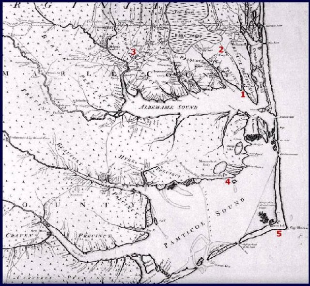
Algonkian Villages in 1733

1. Poteskeet – Currituck County; 2. Yeopim (Weapemeaoc) – Pasquotank (now Camden) County; 3. Chowan – Chowan (now Gates) County; 4. Mattamuskeet – Hyde County; 5. Hatteras (Croatan) – Currituck (now Dare) County.

(Note, the above map and legends are courtesy http://www.ncgenweb.us/hyde/ethnic/algonqin/moseley.htm)

In 1748 a William Williams, Thomas Pugh, Willie Jones, Simon Turner and Zedekiah Stone were appointed “commissioners” for the Tuscarora. (Could Williams be related to Sarah Williams Castellaw, wife of James Castellaw?)

September 20, 1750 a Thomas Pugh sold 150 acres in Duplin County to a William Taylor. The Byrd maps of Duplin County land transactions show a 150 acre tract acquired by our William Taylor in 1754. It is surrounded by lands later acquired by Lewis Barfield, his grandson in law.

March 29, 1753 at a Council Meeting held at New Bern, Thomas Whitmell, John Hill, and William Taylor were appointed by the NC Government to investigate a Tuscarora complaint about a questionable land deal involving Humphrey Bates. (New Bern is located at the confluence of the Neuse River and the Trent River just northeast of New Hanover County and far south from Bertie County.) The land deal involved 300 acres on the Indian Woods Reservation supposedly given to William Charlton by Chief Tom Blount and then sold by Charlton to Bates. As you will see below, Jonathan Taylor, father of William Taylor, knew and had business dealings with William Charlton and Henry Bate as well as Whitmell and Pugh.

November 23, 1763, Sarah Hunter, John Hill and Wm. Williams, executors of the Estate of Henry Hunter in Bertie County pay money to William Taylor and collect money from a Mr. Whitmell.  (Henry Hunter was married to Sarah Whitmell, daughter of Thomas Whitmell II.  Sarah Whitmell Hunter was sister to Thomas Whitmell III, born 1713, died 1779.  Another Whitmell sister married Col George Pollock, another married Henry Bate, and another married Francis Pugh.  Henry Hunter and Jonathan Taylor were involved together in the division of the Estate of John Coward in 1737. Jonathan Taylor also witnessed a deed for John Coward in 1737 involving land adjacent to William Charlton, interpreter for Chief Tom Blount)

1766, a William Taylor was named as a Tuscarora Indian in a lease of 8,000 acres to a William Williams and Thomas Pugh and Willie Jones. This leased land was part of the Indian Woods Reservation. Also named as a tribal member was a John Rogers.  Our William Taylor lived next door to a man named John Rogers in Duplin County. In fact, our William Taylor sold land to John Rogers in 1752 in a deed witnessed by a James Blount.

On January 11, 1769 the English Government approved the lease signed by William Taylor, Thomas Blount, John Rogers and other chiefs of the Tuscarora Tribe to William Williams, Thomas Pugh, and Robert Jones.

Thomas Whitmell was an Indian trader who also acquired Tuscarora Indian lands in a later deed.  According to his will, he lived on the “Kesia” river.  This is probably the same as the “Cashy” near where James Castellaw lived and where Jonathan and William Taylor lived.  According to the Livingston book on the Tuscarora (1752 date), Thomas Whitmell was one of the richest Tuscarora Indians.  In 1733, a Thomas Whitmell witnessed a deed from Jonathan Taylor selling land on the north side of the Roanoke River, probably on or near the Tuscarora reservation.

The Barfields were related to the Taylors.  William Taylor married the daughter of Richard Barfield.  Richard’s grandson Frederick (son of Jesse Barfield and Sara Castellow) married a Susannah Williams in 1779.  Susannah was the daughter of a William Williams.  Furthermore, their daughter, Susan Barfield, married a Needham Bryan around 1800.  The 1761 Bertie county Deed records reference land next to a Capt. Needham Bryan, the Tuscarora Indian, Roquist Pocoson.  It appears that the Bryan Family had Tuscarora blood and that the Barfields married into it.  They may have had other Tuscarora blood – Williams, Taylor, etc. In addition, Sara Castellaw was related to the Williams and one of her brothers married a Tuscarora woman, Martha Butler.

There is a 1724 reference to Barfields Landing along the Meherrin River leading into the Chowan River.  This was originally Cotton’s Landing and is now known as Tuscarora Beach.  Another coincidence????  It is also close to the original site of the Chief Village of the Chowan Indian Tribe, Chowanoke.  The Chowan Tribe was later merged into the Tuscarora.

Another coincidence is the fact that our William Taylor had an uncle named Thomas Taylor, brother to Jonathan Taylor, who was named in a Bertie County Will dated 1724.  He also had a brother named Thomas who was later shown as living next to William in Duplin on Goshen Swamp in the 1750’s. This is important because there was a Chief Tom Taylor who lived in New Bern when Baron Von Graffenreid established his settlement there.  Chief Taylor was run off by Von Graffenreid in 1717 prior to the beginning of the Tuscarora War and disappeared from history.  Could William’s Uncle Tom have been Chief Tom Taylor of New Bern?  When run off from New Bern, did he return to Bertie County and the Indian woods Reservation near his brother Jonathan and nephew William?

A final coincidence is the fact that William Taylor was appointed Commissioner to the Tuscarora in 1753 by a man named James Murray, who was a member of the North Carolina Commission.  James Murray received his appointment to the Commission due to the influence of Henry McCulloh.  This is important because the Grandson of Henry McCulloh, a James McCulloh, married the daughter of our William Taylor.

TIME LINE

1703 Richard Barfield acquires land in Chowan/Bertie/Hertford probably at present day Winton where Barfields, Barfield Landing and Tuscarora Beach are located.

This is also near the site of an original Chowan Indian town—Chowanoke or Ohanoke.

1711-1713 Tuscarora War principally along Neuse and Trent Rivers near New Bern, 60 miles S of Bertie County and 60 miles north of Duplin where William Taylor later settles.

1720 Jonathan Taylor buys 300 acres on E side of Quittsnie Swamp on the Roanoke River.  Prior to this time he was living on Indian Creek in Perquimans County.  This was on or near the site of an ancient Indian Town—Mascoming.

1722/1725 William Taylor born

1723 53,000 acre reservation created for Chowan and Tuscarora tribes along Roanoke River near Quitsnie

1723 Richard Barfield I buys land on Ahotskey Marsh from Henry Baker

1728 Richard Barfield I dies and names daughter Catherine Taylor and granddaughter Elizabeth Taylor in his will

1733 Jonathan Taylor sells 640 acres to George Pollock (son in law of Thomas Whitmell,II)

1737 Thomas Whitmell witnessed deed for Johnathan Taylor at Quitzna swamp & Roanoke River

1741 Jonathan Taylor conveys land to Thomas Blount and Thomas Whitmell located on Rocquis Creek (they were brother’s in law or father/son in law)

1744 Richard Barfield II moves to Duplin County

1745 William Taylor moves to Duplin County with his father Jonathan Taylor

1753 William Taylor, John Hill and Thomas Whitmell appointed Commissioners to Tuscarora Indians.  Hill & Whitmell were brothers in law and grandsons of Henry Hunter.

1753 James Murray was a member of the Council at New Bern which appointed William Taylor a commissioner to the Tuscaroras.  Murray was an associate of Henry McCulloh whose grandson James married our William Taylor’s daughter.

1766 Sale of 8000 acres at Indian Woods to Jones, Pugh & Williams

1787 William Taylor murdered in Duplin County

NOTE:

Thomas Whitmell, II of Bertie County, NC and his wife ? Hunter had a son Thomas Whitmell III.  They also had a daughter Elizabeth who married first George Pollock, possible son of former Gov. Thomas Pollock who was Governor of NC at time of Tuscarora War.  Second she married Thomas Blount, possibly related to Chief Tom Blount of the Tuscaroras.  Third she married William Williams who may have been the man who acquired the 8000 acres from the Tuscaroras.

Another daughter married John Hill and still another daughter married Francis Pugh.

Posted in Tuscarora | 37 Comments

Peta, Half Sioux, Half White, Changed the Face of AIDS

Peta

His name was Peta.  He was a strikingly beautiful man and he lived in a divided world of halves.  He was half white an half Native American, from the Pine Ridge Indian Reservation.  He was also gay.  And he contracted HIV, then AIDS.

Peta was a volunteer who helped others at Pater Noster House, an AIDS hospice in Columbus, Ohio, where he would see clearly before his eyes his own terrible fate unfolding.  He himself would succumb two years later, in 1992.  The Kirby family, whose son, David, Peta cared for in 1990 as he lost his battle with AIDS, would care for Peta on his final journey too.

Peta, along with a young photographer, Therese Frare, would be in the right place at the right time to change the face of AIDS and the perceptions the rest of the Nation had of AIDS patients.

Life magazine has revisited those infamous photographs and tells the story of David Kirby, Peta and Therese in a most memorable article with unforgetable photographs.

http://life.time.com/history/behind-the-picture-the-photo-that-changed-the-face-of-aids/#1

Posted in Sioux | 3 Comments

Indian Status in Canada

If you think that tribal membership and federal recognition and who can be what to whom and why is confusing in the US, take a look at Canada.  One of our readers sent this link. I think it’s well written and explains what our neighbor is doing.

http://apihtawikosisan.com/2011/12/14/got-status-indian-status-in-canada-sort-of-explained/

Hat tip to Paul for this info

Posted in Canada | Leave a comment

Old Indian Photos

Creek

Thanks to Stevie for the link to the Old Indian Photos site.  It’s on Facebook, and this person has categorized old public domain photos of Native people by tribe in 329 Facebook photo Albums.

https://www.facebook.com/NativeHeritageProject/posts/450942961631638#!/pages/Native-American-Indian-Old-Photos/10150102703945578

You can read more about this project at their “About” page, including the album names so you’ll know where to look:

https://www.facebook.com/NativeHeritageProject/posts/450942961631638#!/pages/Native-American-Indian-Old-Photos/10150102703945578?sk=info

Enjoy!

Posted in Photos | Leave a comment

The Kobel Massacre

November 16, 1755 was a dark day for the Henry Kobel family of Berks County, Pa.  It would be their last.

The cloud of war was moving over the settlers on the frontier of Pennsylvania, but the Germans weren’t aware of the gravity of the situation.  Arriving in 1710, they had been pushed from one location to the next by unscrupulous British politicians, to the breaking point.  Twice, they went to live among the Indians, quite successfully. They negotiated with the Mohawks for land and lived as good neighbors, in harmony, until once again, they were told by the British that they didn’t own their land and would have to repurchase it from wealthy British land-owners.  Finally, they wound up in the 1720s on the newly formed frontier in what would eventually become Berks County, living once again next to the Indians, this time, the Delaware.  All went relatively well for many years, but with the advent of the French and Indian War in the 1750s, things changed.  The Delaware, in retrospect, blamed the Germans for pushing them off of their lands.

The Germans thought they were safe.  In their eyes, they weren’t British and they weren’t French.  They had negotiated as Germans with their neighbors, the Indians.

However, the French thought of them as British subjects, which they were.  The Iroquois Indians who were not their neighbors though of them as one more wave of European interlopers taking their lands, and when the French encouraged the Indians to raid the white settlements, the Germans of Bethel Township in Berks County, Pa. were prime targets on the edge of the white settlement, up against Indian villages.

More than one account says that the Germans were warned by friendly Onieda Indians, several times, but the Germans laughed and scoffed at those warning them.   One Onieda Indian said that the Germans “paid not the least regard to what I told them; and laughed at me, slapping their hands on their buttocks.”  They would not laugh long.  Not only did they disregard the warnings in 1755, but again in 1756 and 1757, and again, they were attacked.

Another account says the Germans refused to accept the British troops sent to protect the frontier, believing they didn’t need protection.  After they were attacked, they quickly petitioned for those British troops to return.

The German confidence in their Indian friends and allies was not entirely misplaced.  Yet another report says that over 100 Indians turned back when they realized their target was the Germans, but 250 more proceeded with 90 French to attack their villages and farms.

What we do know, unquestionably, are the results.

Conrad Weiser, a leader in the German community was a man intimately familiar with the Indians, having lived among the Mohawk, with a Mohawk family, as a young man, and was torn apart by this turn of events.  He functioned with ease in both worlds and had for his entire life.

In a letter to Conrad Weiser, Peter Spycker reported on the massacre in Bethel Township on Sunday, November 16, 1755: “John Anspack and Frederick Reed came to me and told me the miserable circumstances of the people murdered this side of the Mountain.  Yesterday, the Indians attacked the watch, killed and wounded him at Derrick Sixth (Dietrich Six’s fort in Bethel Township) and in that neighborhood great many in that night.  This morning our people went out to see; came about 10 o’clock in the morning to Thomas Bower’s house, finding a man dead, killed with a gun shott.  Soon we heard a noise of firing guns; running to that place and found 4 Indians sitting on children, scalping, 3 of the children are dead and 2 are alive, the scalps are taken off…”

Weiser wrote to Governor Morris on November 18 and 19 about the massacre, discussing the event, but not providing the names of those massacred.

Conrad Weiser’s November 19th letter to Gov. Morris:

“On my return from Philadelphia I met in Amity Twp., Berks Co., the first news of our cruel enemy having invaded the county this side of the Blue Mountains, to wit: Bethel and Tulpehocken.  My sons Philip and Frederick arrived from the pursuit of the Indians and gave me the following relation: That on last Saturday, about 4 o’clock in the afternoon, as some men from Tulpehocken were going to Dietrich Six’s place under the hills on the Shamokin road, to be on the watch appointed there, they were fired upon by the Indians but none hurt nor killed (our people were but 6 in number, the rest being behind), upon which our people ran towards the watch-house, which was one half of a mile off, and the Indians pursued them, and killed and scalped several of them.  The first party (of settlers who came the next day) saw four Indians running off.  They had some prisoners, whom they scalped immediately; three children they scalped yet alive, one died since and the other two are likely to do well.  Another party found a woman just expired, with a male child on her side, both killed and scalped; the woman lay upon her face; my son Frederick turned her about to see who she might have been and to his and his companions surprise they found a babe about 14 days old under her, wrapped up in a little cushion, his nose quite flat, which was set right by Frederick and life was yet in it and it recovered again.”

At Reading on November 18, 1755, Captain Jacob Morgan of Colonel Weiser’s regiment deposed that on November 16 he and Philip and Peter Weiser were on their way about 5 o’clock in the afternoon to Dietrick Six’s, that in a house about 9 miles from Conrad Weiser’s they found many people, including a girl of about 6 who had been scalped but was still alive.  Two of their party returned to Tuplehocken to get more powder and shot.  Hearing that the Indians were at George Dollinger’s house, they gathered a party of about 100 men and on November 17, went to Dollinger’s whose family had already left.  Much damage had been done by the Indians.  In the garden they found a girl of about 8 years of age said to the daughter of one “Cola” lying dead and scalped.  They buried her.  They went on the house of one Abraham Sneider, in whose cornfield they found the wife of “Cola” and a child about 8 or 9 years old, both dead and scalped. In the house they found another child of “Cola” about 10 years old dead and scalped.  The buried all three.  Then they went on to Thomas Bower’s house where they found a dead man who had been scalped.

However, Weiser’s letter on November 24th, again to the Governor, provides us with the terrifying details and the identity of the family.

“I cannot forbear to acquaint your Honour of a certain Circumstance of the late unhappy Affair: One….Kobel, with his wife and eight children, the eldest about fourteen Years and the youngest fourteen Days, was flying before the Enemy, he carrying one, and his Wife and a Boy another of the Children, when they were fired upon by two Indians very nigh, but hit only the Man upon his Breast, though not Dangerously. They, the Indians, then came with their Tomhacks (sic) knocked the Woman down, but not dead. They intended to kill the Man, but his Gun, though out of order so he could not fire, kept them off.

The Woman recovered so farr, and seated herself upon a Stump, with her Babe in her Arms, and gave it Suck; and the Indians driving the Children together, and spoke to them in High Dutch, ‘be still we won’t hurt you’. Then they struck a Hatchit into the Womans Head, and she fell upon her Face with her Babe under her, and the Indian trod on her Neck and tore off the Scalp. The Children then run: four of them were scalped, among which was a Girl of Eleven Years of Age, who related the whole Story: of the scalped, two are alive and like to do well. The rest of the Children ran into the Bushes and the Indians after them, but our People coming near to them, and hallowed and made noise; The Indians Ran, and the Rest of the Children were saved…There was about Seven or Eight of the Enemy.”

Certified genealogist Shirley Turner writing in the National Genealogical Society Quarterly in December 1981 relates more about this family and filled in some details.

Henry Kobel and his wife were Mennonites.  The Mennonite faith is a pacifist faith that refuses to fight, even to protect themselves and opposes violence of any kind.  It’s certainly possible that the Kobel family did not defend themselves, even after Henry had been shot.  Perhaps it wasn’t that his gun couldn’t fire, but that he wouldn’t, although from today’s perspective, that is simply difficult for me to imagine.

Both parents were killed of course.  Of their 8 children, we know that 3 were scalped and died that day.  Two more females were scalped and initially survived, but we don’t know if they ultimately survived the scalping or if they died from the results, or from something else.  One would think that having an ancestor who survived being scalped would be noteworthy, but there are no stories of such (that I’m aware of) in the Kobel family or the German descendant community.

The three Kobel children known to have survived, all boys, the two oldest children and the youngest at just 14 days of age, were all eventually baptized back into the Lutheran faith as young adults.  Henry Kobel had been raised Lutheran but had married a Mennonite woman.  Their children were born into the Mennonite faith.

Ultimately, the French and Indian War, also known as the 7 Years War, ended with the signing of the Treaty of Paris in 1763.  Both the French and the Indians lost.  France ceded Canada and the demarcation line of the frontier, ostensibly to protect Indian lands, shown in green below, was pushed westward to the Appalachian Mountains, a line that was never respected and did little to stem the tide of settlers flowing into the Indians’ lands.

Posted in Delaware, Iroquois, Mohawk, Oneida | 85 Comments

The Nemaha People

We covered the Nemaha Reservation earlier, so today, I’d like to talk about the actual records of the allottees.

The alottee record was produced in 1860 when the government was preparing to issue individual allotments to the half-breed people provided for in the Treaty of Prairie du Chien of 1830, which set aside a tract of land for the mixed-race, or Métis descendants of French-Canadian trappers and women of the Oto, Iowa, and Omaha, as well as the Yankton and Santee Sioux tribes.

In total, in 1860 there were about 397 total allottees.  I say about because a few of these people may be listed twice, as they have aliases listed.  For example, a person named Handorum Sharkeppie is also called Canona.

Of these 397 people, a total of 32, or a little over 10%, still carried entirely Native names.  By entirely Native, I mean there was no sign of European hybridization.  Their names were written as Ah-ha-a-me and Ah-pay-we-he, for example.  These names are not transcribed in the Native names project, because descendants could not find them by these earlier names.   Initially I was surprised by the number of people, who were not full-blood, that had Native names.  But then as I thought about it, I realized that, according to the documentation, these children were the results of liaisons between white men and Native women, so it would have been the mothers who were responsible for naming the children – hence – some entirely Native names.

Some names are clearly transitional.  Eliza, daughter of No Heart is a transitional name, as is No Heart.  Both of these names have been transcribed as they are beginning the transition to a European based name.  For example, we have a Josette No Knife.  That surname likely began with a person known as No Knife, and originally, that name would have been recorded in the Indian language.  We see that with the surname Rocco.  We have one person just listed as Rocco, then a second listed as Elizabeth Sister Rocco.  One person is named Stralah.  We don’t know if that was a European name or a name that originated as a Native name.  However, on the list, it is an unhyphenated single name, so it is transcribed into the Native Names project.  The name Whitecould has transitioned from a personal name to a surname with three people carrying that surname.  White Horse isn’t a surname yet, as it is still a single given name.

With some people, the alias is simply a different surname.  For example, the entire O Pelt family is also listed as Ritter, except for one Ritter who is not an O Pelt.  But their first names are the same, so we know the surname, for whatever reason, was not stable.  It could have been used interchangeably.  However, with the person, Alvard Story, alias Silvinie Robedoux, we have no idea why this person has two entirely different names.  The first name doesn’t match.

Of the 365 people who do not have Native names, meaning who have European names, we find 122 different surnames.  On the average, there are 2.99 people with each surname, but that doesn’t hold when you look at the distribution.  The really good news is that most of these names are actually quite unusual.  For example, we have Barrada with 8 people, Benoist with 7 and Deroin with 18.  Of course, to even that out, there are several who have only one person with that surname.  For example, Digyer, Bono and Beans, just to name a few.

Another interesting aspect is that for the most part, if the documentation is correct and these people descend from European fathers and Native mothers, the Y-line DNA test would reveal their European heritage.  On the other hand, if one were to test people who descended from these original couples through all females, the mitochondrial DNA results should indicate a Native ancestor, unless of course there had been an adoption in the line.  Native tribes were notorious adopters of people from other tribes, former slaves and white captives.

To the best of my knowledge, only one photo survives of these Nemaha Half-Breeds, and that is Joseph Deroin, pictured above.  In the 1840s, Joseph Deroin, a ‘Half-Breed’ himself, began operating a trading post along the Missouri River. The trading post eventually became a small settlement known to whites as ‘St. Deroin’ which had a population of 300 in 1900 but was gone by 1912 as a result of repeated flooding.  Today, no trace exists.

Posted in Ioway, Missouria, Omaha, Otoe, Sioux | 4 Comments

Free DNA Intro Webinars

Ever want to find out what DNA testing for genealogy can do for you?  Well, it’s your lucky day.

Sometimes last minute opportunities are the best!  Thanks to the APG, the Association of Professional Genealogists (www.apgen.org), these two webinars are free for everyone.  But act quickly – because the first one is today (Tuesday), November 27th at 9 this evening.  Think of it as a spontaneous date.  Yes, I know more notice would have been nice, but our original session was canceled by the storm and until today, I didn’t realize it was free to nonmembers as well.  So you’re all invited!!!

Session 1:

DNA Explained: An Intro to DNA for Genealogists Tuesday, 27 November 2012 — 9:00 p.m. Eastern Standard Time Presented by Roberta Estes

Join us to learn how DNA can be used for genealogical research. You’ll learn about how DNA testing works for both males and females, including an introduction to Y-DNA, mtDNA, and autosomal DNA. We’ll make science understandable, and by the end of this lecture, you’ll be putting together your own genealogical DNA test plan. Have a pedigree chart handy for quick reference.

Reserve your Webinar seat now at: https://www1.gotomeeting.com/register/659356625

Session 2:

Yikes, My DNA Results are Back! Now What??? Thursday, 29 November 2012 — 9:00 p.m. Eastern Standard Time Presented by Roberta Estes

Have results but aren’t sure what to do with them? This webinar will walk you through how to interpret your results and get the most out them. This presentation covers both Y-line and mitochondrial DNA. Autosomal DNA results will also be discussed in a future webinar.

Reserve your Webinar seat now at: https://www1.gotomeeting.com/register/317067593

Posted in Uncategorized | 2 Comments

Nemaha Half-Breed Reservation Alottees – 1860

The Omaha and other tribes asked the government to set aside territory for their mixed-race descendants. The map above shows Indian villages in 1814 when Lewis and Clark explored in the Nemaha River.

Under the patrilineal systems of the Omaha and Osage, children of white fathers had no place in the tribes. Seeking to help mixed-blood Indian descendants get settled in society, the United States government designated allotments of land in western territory for their use. These were known as the Half-Breed Tracts. Because of American Indian tribes’ rules of descent and membership, European-American society’s discrimination, and the distance that such mixed-race families lived from most European Americans, the children of unions between European fathers and Indian mothers were often left outside the social networks of both societies. Generally Indian women and their French-Canadian trader husbands and children lived under the protection of the women’s tribes, but their descendants were not considered members of the tribes unless they were officially adopted, as they had white fathers, so were considered “white”.

The Nemaha Half-Breed Reservation was established by the Treaty of Prairie du Chien of 1830, which set aside a tract of land for the mixed-race, or Métis descendants of French-Canadian trappers and women of the Oto, Iowa, and Omaha, as well as the Yankton and Santee Sioux tribes.

Located in part of the Indian Territory, which was later in the Nebraska Territory and then the state of Nebraska, the tract’s eastern border was the Missouri River. The reservation extended west for 10 miles. The north/south borders were between the Little Nemaha River to the north and the Great Nemaha River, near Falls City to the south.

Since the land belonged exclusively to the Otoe prior to the exchange, the government worked to secure agreement by the Omaha, Iowa, and Yankton and Santee bands of Sioux to pay the Otoe $3000 for the rights of their “half-breeds” to live on the reservation. Original plans were for land ownership to be held in common, as other American Indian land titles were held. However, legislation included a provision allowing the US President to assign individual tracts to individual owners. In 1860, thirty years after the creation of the Reservation, the government moved to allot tracts to individual households, in an effort to force assimilation to European-American practices. This was the first time in the history of American acts and treaties that American Indians were allotted land in severalty.

The reservation didn’t last long.  In 1861 the Reservation was disbanded as a legal entity. The owners of plots were never required to live on the properties they had been allotted, and many eventually sold their lands to white settlers. Some white men married native women to obtain control of their property.

In order to assign allotments to individuals, a list was taken of the half-breeds.  This list, “Allottees on the Nemaha Half-Breed Reservation, 1860”, adapted for the web by Lance Foster from “the Otoes and the Missouiras” by Berline Basil Chapman, pages 381-384, Appendix A, Times Journal Publishing Company, OK, 1965 can be found at http://scribd.com/doc/104293516/nemeha-half-breed-tract-allottees-1860

No tribes were listed, but we know the Iowa, Otoe-Missouria, Omaha, Yankton and Santee Sioux were represented.  Most people are half-breeds, offspring of a full white father and an Indian mother.  A few many be full-bloods.  Some may be mixed bloods, offspring of half-bloods and half-bloods with various admixtures of Indian, white and perhaps some black.

These half-breed lists are important, because those are the very people whose Native heritage was in jeopardy, in future generations, of becoming lost.  It would be the descendants of these people who are the most likely to be looking for their Native ancestors.

Today, much of this land is encompassed in the Indian Cave State Park.  Indian Cave, located north of the reservation, was a final stop on the Underground Railroad.

Posted in Ioway, Missouria, Omaha, Otoe, Sioux | 3 Comments

Bigfoot is Real???

If a new paper yet to be published and currently undergoing peer review is valid, it appears that Bigfoot, also known as Sasquatch, is indeed, real and a hominid mix, meaning that Sasquatch is a human relative that arose approximately 15,000 years ago as a hybrid cross of modern Homo sapiens with an unknown primate species.

Following five years of research, a team of scientists has sequenced several Sasquatch genomes.  Results show that Bigfoot is a mixture between a human female, about 15,000 years ago, and a male, a previously unknown hominin related to Homo sapiens and other primate species.  Wow.  What a discovery!

This begs several questions.  Is all of the mitochondrial DNA the same, inferring a single maternal ancestor?  They have sequenced 20 different mitochondrial samples.  Given that it’s reportedly identical to that of modern humans, we can presume, one would think, that the mitochondrial DNA is Native American, so a member of haplogroup A, B, C, D or X.  Hopefully the forthcoming paper will be more specific.

The scientists sequenced three Bigfoot DNA samples and the results are stunning.  The male is not a contemporary human and they have eliminated both Neanderthal and Denisovian males as possible founders.

Dr. Melba Ketchum, one of the paper’s authors, states that, “The male progenitor that contributed the unknown sequence to this hybrid is unique as its DNA is more distantly removed from humans than other recently discovered hominins like the Denisovan individual. Sasquatch nuclear DNA is incredibly novel and not at all what we had expected. While it has human nuclear DNA within its genome, there are also distinctly non-human, non-archaic hominin, and non-ape sequences. We describe it as a mosaic of human and novel non-human sequence. Further study is needed and is ongoing to better characterize and understand Sasquatch nuclear DNA. Genetically, the Sasquatch are a human hybrid with unambiguously modern human maternal ancestry.”

The are subtle and not so subtle messages buried her as well.  Obviously, for the team to acquire 20 samples to process, there has to be a population of these creatures living in North America.  Of course, everyone has heard of Sasquatch and seen photos and videos, but until this, nothing has been terribly convincing.  If this is genuine and passes peer review, it not only confirms that Sasquatch is real, it vindicates many of the people who have had “sightings” over the years.  But as with much science, it raises more  questions than it answers.

For example, are there any non-admixed Sasquatch progenitors left, meaning the males that founded the Sasquatch line with the human female?  How would we tell the difference?  This of course implies that some sort of pre-hominid species existed on this continent before Native Americans arrived from Asia and had existed separate from hominids for a long time.  Is there other evidence of this creature in North America?

Where were these samples collected?  Are the Sasquatch samples studied from across North America or from one region only?  Are all of the Sasquatch related to each other, and how closely?  In other words, were there multiple founder events?  Was the Y-line DNA sequenced and what does it tell us? Were there multiple male founders or did the Sasquatch line arise from a “one time” event?  Do any of the Native tribes in these regions have oral history regarding either Sasquatch or interbreeding with Sasquatch type creatures?

Are there “Sasquatch” in other parts of the world as well?  The Yeti or Abominal Snowman of Nepal seems to be similar, and a scalp purportedly exists from that creature.  If DNA samples outside of North American have been sequenced, are they related to the North American Sasquatch or did they arise separately?

And finally, do these creatures have “rights” and are they the same “rights” as humans?  Given that they carry human mitochondrial DNA, and many Native tribes are maternally based, would they be considered “Native American?”  How do we, as humans, deal with this?  Are we learning that humanity is really a continuum?

Indeed, I look forward to seeing this published paper and I hope it is legitimate and not pseudo-science of some sort.  The mere fact that the scientiests have opted for academic publication versus a book or TV documentary certainly alludes to the fact that it is legitimate research.  You can read more about this announcment at these links.  I’ll let you know when the paper becomes available.

http://www.seattlepi.com/business/press-releases/article/Bigfoot-DNA-Sequenced-In-Upcoming-Genetics-Study-4063604.php

http://www.prweb.com/releases/prweb2012/11/prweb10166775.htm

Posted in Anthropology, Bigfoot/Sasquatch, DNA | 4 Comments