Iroquois and Wabanaki Beadwork

Iroquois pincushion

I’ve always loved handwork of all kinds, especially quilting and beading.  My family has some old beadwork that I never realized held clues to our heritage.  After seeing similar pieces, I realized the beadwork pieces I had were carrying a message about who my ancestors were.  Amazing sometimes the clues we miss.

There’s a great blog about Iroquois, Wabanaki and Penobscot handwork, in particular, beadwork, and heritage.

http://iroquoisbeadwork.blogspot.com/

Part 1 – http://iroquoisbeadwork.blogspot.com/2013/01/wabanaki-beadwork-part-1.html

Part 2 – http://iroquoisbeadwork.blogspot.com/2013/01/wabanaki-beadwork-part-2.html

The person who write this blog, Gerry Biron, has also written books and articles on the subject – http://www.gerrybiron.com/pages/publications.html

Here’s their website – http://www.gerrybiron.com/

Enjoy.

Posted in Abenaki, Iroquois, Penobscot | 2 Comments

Full Moon Native Names

full moon

The first full moon of 2013 will light up the night sky tonight (Jan. 26), but did you know it’s a full moon of many names?

Full moon names date back to Native American tribes of a few hundred years ago who lived in what is now the northern and eastern United States. Those tribes kept track of the seasons by giving distinctive names to each recurring full moon. Their names were applied to the entire month in which each occurred.

There were some variations in the moon names, but, in general, the same ones were used throughout the Algonquin tribes from New England on west to Lake Superior. European settlers followed their own customs and created some of their own names. Since the lunar (or “synodic”) month is roughly 29.5 days in length on average, the dates of the full moon shift from year to year.

Here is a listing of all of the full moon names, as well as the dates and times for 2013.

http://news.yahoo.com/moon-swoon-2013s-full-moons-got-peculiar-names-143423946.html

Posted in Algonquian, History | Leave a comment

The Traveling Tuscarora

Fletcher Freeman has once again graced us with one of his excellent  research papers.  Thank you, Fletcher, for sharing, and for continuing the quest!

The Traveling Tuscarora

By Fletcher Freeman

At first contact by the English, the Tuscarora were located in what is now North Carolina between the Roanoke and Chowan Rivers and around New Bern along the coast. In 1711 they rebelled against the colonists in the Tuscarora War.  Subsequently they were given a 56,000 reservation along the Roanoke River but sought permission to join the Five Civilized Tribes in New York, which they did beginning in 1713 and continuing to 1802.  You see, the Tuscarora were of the Iroquois Language Group as were the Five Civilized Tribes-Seneca, Oneida, Cayuga, Mohawk, and Huron.  Other Iroquois language speakers in Virginia and the Carolinas were the Cherokee and Meherrin.

Why did the Tuscarora migrate some 1,500 miles north to join the Five Civilized Tribes?  Going back into times unknown there was a path or trail or road known as the Great Indian Trading Path a/k/a Great Indian Warpath a/k/a Seneca Warpath that ran from Niagara Falls in present day New York to Mobile Bay in present day Alabama.  Native Americans went North and South for centuries before the arrival of Europeans, trading and waging war.  This path passed through Virginia East of the Appalachians into North Carolina just west of the Chowan River and over into Georgia and Alabama to the Gulf of Mexico.  There is no record that the Indians traversing this path had horses and the canoes used in the southeast were heavy dug outs as opposed to the lighter weight birch bark canoes used in the north.  As a result, most travel must have been on foot.

The Tuscarora were a proud and powerful nation, claiming most of the Coastal Plain, from near the Virginia border south to the Cape Fear River and west to the Piedmont. At their apex, they may have numbered as many as 6,000 warriors in 24 large towns, the heart of their settlements lying between the Neuse and Pamlico rivers along Contentnea Creek. Their lands spanned the present day locations of Raleigh, Smithfield, Goldsboro, Wilson, Rocky Mount, Tarboro, Greenville, and Kinston. Of the many tribes in Carolina, none but the Cherokee was as strong.

There is some indication that the Tuscarora were also located in the area of New Bern along the Carolina Coast prior to the arrival of Baron De Graffenreid in 1710.  He acquired land for a colony from a group of Indians believed to be Tuscarora.  His dealings and treatment of this band may have instigated the Tuscarora War.

Following the Tuscarora War in 1711-1713, the Tuscarora sought and obtained permission to join their fellow Iroquois speakers in New York along the Canadian Border where they live to this day.  Some remained in North Carolina, but lost their identity and were merged with other tribes or became classified as “mulattoes.”

The question this paper attempts to answer is how far west did the Tuscarora travel?  We know they had trails that  went as far North as Canada, as far South as the Gulf of Mexico, and as far East as the Atlantic Ocean. It is my belief that the Tuscarora of North Carolina roamed as far West as the Mississippi River.

Fortunately there is a historical record that may answer this question.  The evidence is circumstantial, but in the American Judicial System circumstantial evidence is acceptable and often utilized.

Marquette and Joliet were two French explorers in the late 1600’s.  In 1673 they discovered the Mississippi River and followed it almost to the Gulf of Mexico.  They started in present day Green Bay, Wisconsin and followed the Wisconsin River to Prairie de Chien where they entered the Mississippi and headed South.  Near the Ohio River they met a band of Indians on the riverbank and stopped to visit.  Father Marquette spoke Huron, an Iroquois language and the Indians were able to communicate with him in that language.  Marquette also noted that these Indians wore Iroquois style leggings and had guns, knives, axes, and crucifixes of European origin.  He surmised that they traded with Europeans, possibly Spanish in the Southeast near Florida.  Marquette and Joliet proceeded farther south along the Mississippi and several weeks or months later headed back north where they once again met these same Indians.  Marquette composed a letter, in Latin, that he gave to the Indians and asked them to take it to their European Friends.  Two years later it was delivered to William Byrd, who lived along the Virginia-North Carolina Border in Tuscarora Country!

We will never know for sure if these were Tuscarora, but they dressed in the Iroquois (Tuscarora) fashion, they spoke Iroquois (Tuscarora) and their home was Virginia-North Carolina (Tuscarora Territory)

SOURCE DOCUMENTS FROM THE WISCONSIN HISTORICAL SOCIETY LIBRARY ARCHIVES found at http://www.wisconsinhistory.org/diary/cat_marquette_and_joliet.asp

Historic Diaries: Marquette and Joliet

Wisconsin Historical Society

July, 1673: Signs of Europeans

Marquette and Joliet passed the site of modern St. Louis during the days that are tersely summarized in the opening sentence of this entry.

Scholars suspect the encounter with the Indians took place in the vicinity of modern Memphis, Tennessee. Who these Indians were has never been ascertained. Had they been a southern band of Illinois, Marquette and Joliet would have found it easier to communicate with them. Their trade goods are thought by some scholars to have come from English settlements in the East, because Spanish goods were not allowed up the Mississippi by powerful tribes nearer to its mouth; and their cursory acquaintance with Christianity may have come from Franciscan missionaries operating in Georgia. These suppositions have led some researchers to suggest they may have been related to the Chickasaw. The explorers will meet them again on the way back upriver, when they will perform a very unusual and remarkable service.

“Manitou” was the European translation of a word in Algonkian languages that as a noun denoted a spirit being, and as an adjective carried connotations of holy, sacred, or spiritual. We hear it today in the Wisconsin place name of Manitowish Waters. In one of the ironies of cross-cultural contacts, the missionaries typically identified such beings as devils, and so rather than being thought of as holy or sacred, many places in the northeastern parts of the continent bear the adjective “Devil” or “Devil’s” in their name – – the direct opposite of how the Indians thought of the location.

Marquette’s Journal: “After proceeding about twenty leagues straight to the south, and a little less to the southeast, we found ourselves at a river called Ouaboukigou [the Ohio River], the mouth of which is at the 36th degree of latitude. Before reaching it, we passed by a place that is dreaded by the savages, because they believe that a manitou is there, that is [word missing] to travellers; and the savages, who wished to divert us from our undertaking, warned us against it. This is the demon: there is a small cove, surrounded by rocks twenty feet high, into which the whole current of the river rushes; and, being pushed back against the waters following it, and checked by an island near by, the current is compelled to pass through a narrow channel. This is not done without a violent struggle between all these waters, which force one another back, or without a great din, which inspires terror in the savages, who fear everything. But this did not prevent us from passing, and arriving at Waboukigou [the Ohio River].

“While drifting down with the current, in this condition, we perceived on land some savages armed with guns, who awaited us. I at once offered them my plumed calumet, while our Frenchmen prepared for defense, but delayed firing, that the savages might be the first to discharge their guns. I spoke to them in Huron, but they answered me by a word which seemed to me a declaration of war against us. However, they were as frightened as we were; and what we took for a signal for battle was an invitation that they gave us to draw near, that they might give us food. We therefore landed, and entered their cabins, where they offered us meat from wild cattle and bear’s grease, with white plums, which are very good. They have guns, hatchets, hoes, knives, beads, and flasks of double glass, in which they put their powder. They wear their hair long, and tattoo their bodies after the Hiroquois fashion. The women wear head-dresses and garments like those of the Huron women.

“They assured us that we were no more than ten days’ journey from the sea; that they bought cloth and all other goods from the Europeans who lived to the east; that these Europeans had rosaries and pictures; that they played upon instruments; that some of them looked like me, and had been received by these savages kindly. Nevertheless, I saw none who seemed to have received any instruction in the faith; I gave them as much as I could, with some medals.

“This news animated our courage, and made us paddle with fresh ardor. We thus push forward, and no longer see so many prairies, because both shores of the river are bordered with lofty trees.”

Historic Diaries: Marquette and Joliet

Wisconsin Historical Society

Aug. 4, 1673: A Letter from Memphis

Marquette’s letter given here ultimately made its way from the Mississippi to William Byrd, in Virginia, and then into a British manuscript collection. It was first discovered and published in 1920; this English translation is from Donnelly, Joseph P. Jacques Marquette, 1637-1675 (Chicago: Loyola University Press, 1968), page 227. It was first published in Clarence W. Alvord, “An Unrecognized Father Marquette Letter,” American Historical Review XXV (1920): 676-680.

Marquette’s letter: Near the site of modern Memphis, Marquette and Joliet again encountered the band whom they had met a month earlier. Knowing that they had communicated with Europeans, Marquette drafted the following letter in Latin and gave it to the Indians. Its language suggests that he expected it to find its way to the Spanish Catholics in Florida:

“I salute in the Lord whoever receives this letter.

I, who am nothing, except by virtue of obedience, seeking to lead anyone I could to Christ, our Saviour, happened, under divine direction, to meet Indians whom I believe are in contact with Europeans. Since they could not give me any information about this, I should like to learn who you are, where you live and who these Indians are. In the meantime know this about me. God called me to the Society of Jesus so that in this region of Canada I might spend my life working for the salvation of the Indians whom He redeemed with his Blood. I am certain that if the Immacualte Virgin Mother of God were present to me in this pitiable country, she would not wish me to render up my soul, which Christ saved with such bitter torment and she preserves, until I succeeded. Let us each pray that if we do not meet in this life we may do so in heaven.

“Done on the River of the Conception

At the 35th latitude and

Approximately the 275th longitude

4 August 1673

“Your servant in Christ Jesus

And the Immaculate Conception

Jacques Marquette Societ. Jesus”

Miraculously, this letter actually reached Col. William Byrd in Virginia more than two years later.

Joliet’s map of their travels is shown below.

Marquette 1681 upright

Posted in Uncategorized | Leave a comment

Lake Baikal as an Ice Drum

Lake BaikalAs most of the folks who follow this blog know, the ancestors of the Native Americans were originally found in the Lake Baikal area of Asia, tens of thousands of years ago.  This area in many ways is our homeland.

Lake Baikal itself is amazing, over 25 million years old, it is the oldest and deepest lake in the world, and it freezes each winter.  A UNESCO World Heritage site, it contains 20% of the world running fresh water, also making it the world’s largest reservoir.

However, the ice there has special qualities that cause it to be “musical” for lack of any better description.  Drummers make beautiful music using the ice on the lake itself.  Surely is resonant of Native drumming.  I have to wonder if Native drumming began on this ancestral ice.

Take a look at this article and be sure to scroll down and listen to the video so you can hear for yourself.

http://www.dailymail.co.uk/news/article-2255943/Listen-Siberian-ice-drummers-use-frozen-Lake-Baikal-incredible-musical-instrument.html

Hat tip to Melissa for this info.

Posted in Lake Baikal | 2 Comments

Tuscarora White Deer Clan

Rickard, Clinton chief

There has been a discussion about the Tuscarora White Deer Clan.  Much uncertainty exists about the clan, and how or why it came to be.

Some comments involving this clan are politically motivated.  I try very hard to distance myself from that type of thing, but sometimes it’s difficult to tell what does and does not fall into that category.

A fellow researcher told me that the white deer clan was the result of the adoption of a white female child into the Tuscarora when they lived in North Carolina.  The question, of course, was whether or not this could have been Virginia Dare, the daughter of Lost Colonists, Ananias Dare and his wife Eleanor White Dare.

The results of my poking around found some videos and other online “documentation” that reported that the White Deer Clan was only formed in the 1980s as a political move related to tribal office.

It seems to me that there was a very large difference between the 1980s and the 1700s, given that the last of the Tuscarora formally removed from NC to NY in 1803.

I began searching for something a little more definitive, but I found nothing in my resources. I often refer to the Elias Johnson book, “Legends, Traditions and Laws of the Iroquois, And History of the Tuscarora Indians,” but on this topic, trusty Elias was silent.

Then Chris sent me a link to a page in the book,
Fighting Tuscarora: The Autobiography of Chief Clinton Rickard (1882-1971), published in 1973 by Chief Rickard.  Clearly, 1973 is before the 1980s, so whatever the chief had to say predated the information alleged about the 1980s.

Here’s what Chief Rickard had to say:

Rickard page

Based on the Chief’s information, we can determine that this white child was not Virginia Dare. Virginia was not a member of a set of twins, nor did she live when the Tuscarora and English were in conflict, in the early 1700s, in North Carolina.

I tried to find a photo of Chief Rickard, but little has been published about him.  A statue has been placed at Niagara Falls on the Indian reservation in honor of Chief Rickard. You can see the statue above and find the location here.

Chris, the gentleman who sent me the link to Chief Rickard’s autobiography said that he had seen another story related to the White Deer Clan that suggested the adoption of the white female was earlier, but he was unable to find that reference again.  If anyone finds any references to the White Deer Clan, historically, please leave a comment with the information and source, or e-mail me please.  And a big thank you to Chris for this info.

Posted in Tuscarora | 1 Comment

The Lost Colonists and Edward Bland’s 1650 Expedition

In 1650, Edward Bland and others explored “New Brittaine.” A pamphlet published in London the following year told of the voyage to the Chowan, Meherrin, and Roanoke river area.

On August 27, 1650, a Virginia exploring party set out from Fort Henry (current day Petersburg) to reach the Tuscarora settlements. The company included Edward Bland, Abraham Wood, Sackford Brewster, Elias Pennant, two white servants, and an Appromattox Indian guide. On the way they secured a Nottoway Indian guide named Oyeocker.

While later explorers would also visit these areas, Bland’s expedition was unique because they were searching for, among other things, English people who were rumored to be living among the Tuscarora in current day North Carolina. These people were thought to be either Sir Walter Raleighs Lost Colonists from 1587, or perhaps their descendants, given that it has been 63 years since the colony was “lost,” or accidentally abandoned on Roanoke Island.

In the book, Westward from Virginia: The Explorations of the Virginia-Carolina Frontier 1650-1710, Alan Vance Briceland covers this expedition as well as the others that followed, tracking them as best as we can given the information provided.

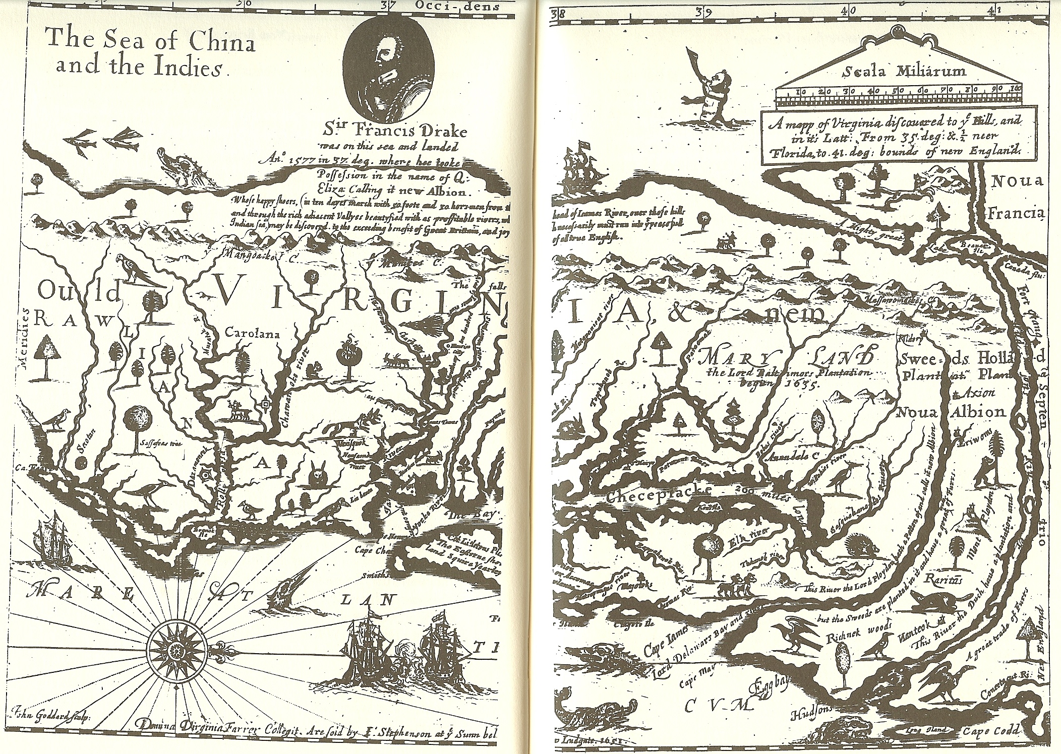
In Bland’s pamphlet, The Discovery of New Brittaine, he included a map of the area he explored. North is to the right.

 Bland 1650 nap

The area where the colonists were believed to have been located is shown below.

 Bland 1650 nap

I have excerpted several sections from “Westward from Virginia.” I would heartily recommend this book, but it is unfortunately out of print today, making it very difficult to acquire. Excerpted sections in italics.

Page 9 – The Bland-Wood exploration of 1650 to “New Britainne” is generally depicted as a typical mid-century Indian trading expedition. It’s uniqueness lies only in the fact that an account of it has survived.

Page 29 – Although the title page states that the 6 Englishmen of the Bland-Wood party and their native guide reached a destination 120 miles to the southwest, an area Bland called “New Britain,” both the route followed and the location of New Britain have been surrounded with mystery and subject to a variety of interpretations. Historians and ethnologists have suggested a number of routes and destinations, ranging widely across southern Virginia and eastern NC. Because Bland stated that the explorers reached the “first River in New Brittaine, which runneth West”, one historian concluded that Bland and his companions reached the New River in southwestern Virginia. An ethnologist has placed Bland’s travels “to the west of the falls of the James River” among the Indians of “central and south-central Virginia.” But others have envisioned the party as far south as Fishing Creek, NC, 20 miles beyond the Roanoke River below Roanoke Rapids, or even at the mouth of the Roanoke on Albemarle sound.

A majority of scholars have located Bland’s New Britain near Clarksville in Mecklenburg, Co., Va [see map]. Seventy give miles southwest of Fort Henry and the falls of the Appomattox, the site is where the Staunton and Dan Rivers united to form the Roanoke River before the John H. Kerr Dam flooded the area in 1949. Although Bland’s narrative does not indicate the direction of travel consistently, when it is given, it is always to the west of south. In the first 5 days of travel the only direction stated other than “south and by west” is a 2 mile detour to the southeast in order to ford a river. The party began the return journey on the afternoon of the 6th day by traveling “north east”, “north and by east and due north.” This it appears that the party traveled in a reasonably straight line between south and southwest outbound and between north and northeast on the return journey. The Clarksville site is southwest of Fort Henry’s location, now Petersburg.

P 32 – Although actually less than the 120 miles Bland specified, the distance to Clarksville is a reasonable 4 days journey by horse and allowing for the probability that the early travelers could not keep to a perfectly direct course, conforms to Bland’s account. The striking geographic features in Bland’s description of New Britain are islands and falls in a river at a place where the Indians caught sturgeon. William Byrd’s “Journey to the Land of Eden” contains his 1733 description of Saponi, Occaneechee and Totero islands, of the shallows there, and of the Indians fishing in the Roanoke, Byrd’s Eden was at Clarksville.

Another attractive feature of the Clarksville hypothesis derives from the supposed existence of the Occaneechee Path. William E. Myers definitive study of “Indian Trails of the Southeast” characterizes the doubtless prehistoric path as leading from Fort Henry southwestwardly to the “important Indian trading town of the Ocaneechi” on their island “near what is now Clarksville.” Why would Bland’s party, “intending a southwesterne discovery,” have wandered about in the woods in search of trade when a well-worn path beckoned to an “important Indian trading town?”

The long and short of this is that we don’t know exactly where they were located. This only matters in that we are trying to approximate the location where the English would have been living among the Tuscarora. Briceland provides the following maps in his book. Three of the four proposed routes take the Bland party to a location on the Roanoke River near the border of Virginia and North Carolina.

westward map 1

 westward map 2

P 45 – In Bland’s pamphlet, The Discovery of New Brittaine, he recorded that on two occasions natives asked the explorers to explain their motives. When questioned by a Nottoway chief, Bland’s explanation was “the Tuskarood King had envited us to trade, and our governoour had ordered us to go and speak with an Englishman amongst them, and to enquire for an English woman cast away long since, and was amongst those Nations.” When the Meherrin Indians asked, he answered that “the cause of our comming was to trade in any way of friendship.”

If this English woman was Virginia Dare, born in 1587, she would have been approaching her 63rd birthday in August of 1650. If the colonists survived, there were likely additional children born after they were left on Roanoke Island.

P 46 – It is quite likely, as Bland told the Meherrin Indians, that colonial officials were highly intrigued by stories of an Englishman and an English woman separately living among the Tuscarora. For 60 years Englishmen had pondered the fate of the lost colony of Roanoke Island. If Virginia Dare was still alive, she would have been 63 and any surviving descendants of the Raleigh settlers would have been considerably younger. Word of Englishmen among the peoples in the vicinity of Roanoke Island even as late as 1650 may have aroused a glimmer of hope that the great mystery of English colonization might still be solved. If the Englishmen turned out to be Spanish or French, that too was worth knowing.

P 49 – When they sent a runner to the Tuscarora, they instructed him to seek out the mysterious Englishman and to tell the Indian king that a party of Englishmen wished to present him with a gift. Nothing was mentioned of trade [although that was the official reason for the trip]. Later when members of the Hocomawananck tribe of Tuscarora Indians visited members of the English camp near the Roanoke River, Bland recorded no discussion of trade. Then the runner sent to the Tuscarora king returned with the king’s son to arrange a meeting, the conversation focused upon the mysterious Englishman, not on trade.

P 50 – The only Virginians known to have traveled in the general area reached by Bland and Wood were John Pory in 1622 and a military expedition dispatched by Gov. Berkeley to the Chowan River in 1646. Pory recorded only a few comments about the vastness of the forest between the James and the Chowan. The military expedition, led by Col. Thomas Dew, went by boat south along Currituck Inlet, west along Albemarle Sound, north into the Chowan River. Major Richard Bennett led a second overland portion into the same area.

P 52 – It is not known from whom Plumpton and Tuke [two English men] purchased their claims, but at almost exactly the same time the identical tract of land was sold by the Tuscarora to the Weyanoke who lived upon and used the land for some years thereafter.

In the fall of 1653 Francis Yeardley a member of the house of Burgesses encouraged Nathaniell Batts to explore Albemarle Sound with an eye to opening a trading post and in 1654 or early 1655 employed a carpenter “for building a house…for Batts to live in and trade with the Indians.” The house was constructed at the west end of the sound below the mouth of the Chowan River and Batts became the first Englishman known to have resided west of the Chowan.

On the 1733 Mosely map below, you can see “Batts Grave” which is most likely, Batts Island. Given that Batts settled just 3 years after Bland’s expedition, one would think that if there were indeed English among the Tuscarora, Batts would have been aware of it and perhaps recorded it in some fashion.

 batts grave

P 54 – Charles the II had just sent instructions to Berkeley to grant a commission for exploration. He had been informed that an Englishman and an Englishwoman were said by the Indians to be living among the Tuscarora. Most importantly, he was anxious about the safety of the southern frontier.

P 68 – In August 1650 Edward Bland and Abraham Wood led 4 other Englishmen on the 9 day exploration through the territory of the Nottoway, Meherrin, Weyanoke and Tuscarora Indians. Bland included in “The Discovery of New Brittaine” an account of their encounters with several Indian groups which were at the time sufficiently isolated from the English that they were not yet tributaries. Bland described the Nottoway and Meherrin, 2 groups about which other 17th century observers said almost nothing.

P 73 – Chounterounte [a Nottoway] was undaunted. He “demanded of us” said Bland, “whither we did intend to go.” The English replied that “the Tuskarood King had envited us to trade, and our Governour had ordered us to go and speake with an Englishman amongst them, and to enquire for an English woman cast away long since.” Having elicited their goals, Chounterounte declared that he knew that there were no English, male or female, among the Tuscarora. Since that was their mission, they need go no further. As to the invitation to trade, “the way was long,” and there were “many rotten marrishes and swampps…to passe over.” Their quest was not feasible.

The Nottoway were not terribly friendly, and a pattern of deception began here with a Nottoway pretending to be a Tuscarora chief. Bland’s Indian guides became increasingly uneasy.

P 79 – Thus, the pattern of contact was set. On at least 2 other occasions when important Meherrin figures, a werrowance and “the old King Maharineck”, wished to speak with the English, they, in Bland’s words, “came to us.”

The English were not the only visitors in the Meherrin village. A Tuscarora Indian was also there. Since at least one of the purposes of Bland’s journey was to check out stories of an Englishman among the Tuscarora, the party questioned him and were told that there was indeed a European among his people, “a great way off at the further Tuskarood Towne.” Excited by the news, Bland hired the Tuscarora to act as runner and messenger. He was instructed first “to run before and tell his Werrowance wee intended to lay him down a present at Hocomowananck.” He was then to find “the Englishman” and deliver a written message informing him that an English party would be at Hocomawananck 3 days hence and desired to meet with him. Bland suspected that the term “Englishman” might include all Europeans, so the message entrusted to the runner was written not only in English but also in Latin, Spanish, French and Dutch. The Tuscarora runner promised to deliver the messages and “in 3 dayes to meet us at Hocomawananck.”

The further Tuscarora town could have been on or near the Neuse River where the Tuscarora Villages were known to exist some time later. There were several villages between the Neuse and the Roanoke River/Albemarle Sound region.

P 80 – Bland was never to know it, but “the Englishman” was Spanish. In the fall of 1653 an English party financed by Francis Yeardley visited a hunting camp of the Tuskarorawes emperor,” who invited them to his town. There, he told them, “was one Spaniard residing, who had been 7 years with them, a man very rich, having about 30 in his family, 7 whereof are negroes.”

P 81 – For the time being, the false “Werrowance” deceived the Englishmen. He convinced Bland that he was “very joyful that wee could goe thither” and explained, probably with a fair knowledge of the situation, why there had been so little contact between the Tuscarora and the English. The principal impediment had been the Weyanoke, who had been driven from their traditional lands along the James after the uprising of 1644. The English knew they had located temporarily somewhere near the Chowan River; in actuality, they lived on Cutawhiskie and Potecast creeks near present-day Ahoskie, North Carolina (some 35 miles southeast of the Meherrin and 25 miles east of the Hocomawananck branch of the Tuscarora).

This identified the location pretty specifically. If accurate, this confirms that Bland was indeed on the Roanoke River someplace near Roanoke Rapids.

P 84 – “About 3 hours after we had taken up our quarters” reported Bland, “some of the inhabitants came, and brought us roasting ears and sturgeon.” Early the next morning the local natives returned to the English camp to construct a house for the explorers use. Three characteristics of the Hocomawananck people set them apart from other Indian groups known to Bland: many of them wore beards, there were “many very old men,” and the inhabitants were “full of children.”[1] The beards worn by the older males of this region allowed Bland to see a disparity in age distribution: he noted an unusually large number of older men and children in comparison with the number of younger men. The younger men may have been out hunting, but it is also possible that an unusually large number of warriors had died. Bland said little about the material wealth of the Hocomawananck. He saw copper ornaments and was told that “they tip their pipes with silver.” The Hocomawananck possessed significant wealth in the form of the sturgeon they caught below the falls.

Native American men do not have much body hair and generally do not, and cannot, grow beards. This would confirm European admixture although it does not confirm that the admixture is from the colonists.

P 85 – Beside the Roanoke, the English began to sense that their situation was more dangerous than they had realized. Pyancha and Oyeocker were obviously uneasy. They had cautioned on arrival that the Hocomawananck were normally “very treacherous” and after a few of the Indians visited the camp, the guides “did not like their countenances, and shape well.” The night passed without incident. The following day was to be spent examining the area. The day after that was the appointed day for meeting the Tuscarora and for learning the whereabouts of the mysterious Englishman and the missing Englishwoman. These expectations were suddenly and decisively dashed early on the 6th morning by a short out burst from a frustrated Oyeocker. He demanded of Pyancha to know why “we did not get us gone” from this place. The Hocomawananck, he asserted, were “jealous of us and angry with us.”

The party moved away from Hocomawananck where they were to rendezvous with the Tuscarora and headed some 6 miles northeast.

So close, but so far away. Had the rendezvous occurred, we might today know if the colonist had survived. If they did, their DNA would surface among at least the Tuscarora, if not other tribes as well.

  Bland trip

The map above shows relevant locations from the Bland expedition. The top left red arrow is the location of the Meherrin Indian Village, and the arrow on the right depicts the second Nottoway Village visited.

The red arrow at Roanoke Rapids depicts the location of the Hocomawanack (Tuscarora) Massacre.”

Bland says “3 miles east of the island in the Roanoke, just north of Weldon NC, Bland in 1750 came upon a place where “several gret heapes of bones” were plainly visible.” The Powhatan slew 240 of the Hocomawananck Indians.

The village where the Hocomawanack Indians lived was 3 days from approximately this location on a river named for them, but renamed Blandina by Bland. This was possibly the Roanoke. The small red arrows that show the Roanoke River which travels northwest to southeast this point. The large red arrow near Williamston points to the location of the eventual Indian Woods Tuscarora reservation in Bertie County, also located on the Roanoke River. We know that the Tuscarora lived in this vicinity when white men first settled there. By 1711, the Tuscarora Chief, Blount, had adopted the surname of the white Blount family living adjacent the Tuscarora village in the area that would become Bertie County, NC.

Based on physical information regarding Tuscarora beards, it appears that adult Tuscarora are admixed, meaning the admixture would have occurred before 1630. Bland did not say that only young men had beards. If both young and old men had beards, then the admixture would have occurred sometime before 1600, a time that would align well with the colonists. The explorations by Lane and others in the 1585-1587 timeframe did not record anything about Indians with beards, so that admixture would appear to have occurred between 1587 and about 1600, and certainly before 1630.

It would appear that at a Spaniard and his family, including possibly slaves, of which 7 are negro, was living among the Tuscarora and had been since about 1646, but the Tuscarora are not described as having negro traits. If the slaves intermarried with the Tuscarora, the next generation may have been admixed.

It also appears that possibly at least one English male and one female may have been living among them as well, depending on who you believe. They may well have been elderly at this point because we hear no more about them in 1653 when Nathaniel Batts settles in that area or when the 1653 Yeardley expedition that documented the Spaniard visits the Tuscarora village. There were a few English couples that settled on Roanoke Island in 1587, so it’s certainly possible that some non-admixed children were born for several years after the colony was abandoned. There were a total of 17 English women, of unknown ages, plus Virginia Dare born in 1587.

Certainly, 63 years later, the colonists, or their children and grandchildren did not wish to be “rescued” anymore.  They may not have wanted to be identified for fear of being forcibly removed. The would no longer have been English colonists, but part of the Native American cultural family. So perhaps after their 1650 close encounter they simply melted into the forests and swamps.

This information also begs the question of what happened to the family of 30 Spaniards and negroes.  Surely some had intermarried.  Were they simply absorbed by the Tuscarora? It appears that the Tuscarora were already admixed by 1650 and by the next generation, if the negroes assimilated as well, would have been tri-racial.


[1] Narratives of Early Carolina 1650-1708, Vol 11 by Alexander Samuel Salley, p 13-19, http://books.google.com/books?id=rRMOAAAAIAAJ&pg=PA16&lpg=PA16&dq=blandina+river&source=bl&ots=76z3H5WWvk&sig=1fqjFA-UhSk_p9NOriJFnch5tfs&hl=en&sa=X&ei=0UHjUJ_iPJSrqQHW9YHwBQ&ved=0CDgQ6AEwAQ#v=onepage&q=blandina%20river&f=false

Posted in Appomattox, Meherrin, Nottoway, Tuscarora | 2 Comments

The Lost Colony in Clarksville, Virginia???

Well, you just never know where that elusive Lost Colony is going to turn up next.

While researching something else entirely, I stumbled across William T. Mitchell’s writings at this site:

http://www.victorianvilla.com/sims-mitchell/local/native/redis.htm

Mitchell provides the following information

Douglas L. Rights, The American Indian in North Carolina, John F. Blair, Winston-Salem, NC, 1957. Rights attempts to connect historical references to Piedmont tribes with specific archaeological sites, an attempt probably unsuccessful in comparison to Dr. Briceland’s study mentioned above. Rights’s book, however, does give a fascinating overview of the Piedmont tribes. Among his many fascinating conclusions is his assertion that the last survivors of the Lost Colony took up residence near Clarksville, Virginia. (John Smith’s May 1609 letter to the Virginia Company of London stated that four English were alive under the protection of Gepanocon at the location of copper mines at the town of Peccarecamicke. — On this topic, see also this author’s article “Roanoke Island’s Lost Colony: A Note.”)

Clarksville Va

Where, exactly, is Clarksville, Virginia? It’s on the border of Halifax and Mecklenburg County, Virginia, just slightly north of the Virginia, North Carolina border, shown with the red balloon on the above map.

Ok, I’m game, let’s take a look at “Roanoke Island’s Lost Colony: A Note,” edited by Henry Mitchell: http://www.mitchellspublications.com/articles/hhm/0018/

Mitchell says:

The following is found in “Captain Newport’s Discoveries in Virginia,” Transactions and Collections of the American Antiquarian Society, vol. 4, John Wilson & Son, Boston, Massachusetts, 1860, p. 61. The passage is referenced as being from William Strachey, History of Travaile into Virginia Brittania, published by the Hakluyt Society in 1849 from a manuscript in the British Museum.

As I mentioned in the text of my 1997 article “Rediscovering Pittsylvania’s ‘Missing’ Native Americans,” in years past I have talked to Halifax County (Virginia) residents whose families have a long tradition of descent from local Native Americans and the very first English settlers. In endnote 9 of that article, I mention that Douglas L. Rights, in his book The American Indian in North Carolina (John F. Blair, Winston-Salem, North Carolina, 1957), asserts that the last survivors of the Lost Colony took up residence near Clarksville, Virginia. The text below appears supportive of that conclusion; it is not clear whether it was one of Rights’ sources.

According to this account from William Strachey, the surviving Roanoke colonists would have escaped to places called Ritanoe, Ochanahoen, and Peccarecamek [near today’s Clarksville?], where they lived under the protection of, and worked in the copper mines of, the Weroance [chief] Eyanoco.

“At Peccarecamek and Ochanahoen, by the relation of Machumps,(1) the people have houses built with stone walls, and one story above another, so taught them by those English who escaped the slaughter at Roanoak, at what time this our Colony, under the conduct of Capt. Newport, landed within the Chesapeake Bay, where the people breed up tame turkeys about their houses, and take apes in the mountains; and where, at Ritanoe, the Weroance Eyanoco preserved seven of the English alive — four men, two boys, and one young maid (2) (who escaped, and fled up the river of Chanoke) — to beat his copper, of which he hath certain mines at the said Ritanoe; as also at Pamawauk are said to be store of salt-stones.(3)”

Notes

1. An Indian subsequently mentioned.

2. Was this Virginia Dare, the first-born Anglo-American? She or “— Harvie” are the only two on the list of that colony, as White left it, who could have been spoken of as “maids” in 1607. There were boys, but no other girls, among them.

3. Page 26.

Posted in Lost Colony | Leave a comment

Pittsylvania County, Virginia, Native American Locations

Byrd Pitts Map

I’ve discovered a lovely website created by William T. Mitchell.  William Mitchell is a historian with a particular interest in Pittsylvania County, Virginia, which sets atop the dividing line between North Carolina and Virginia.  This area is rich in history, with Col. William Byrd being one of the first Europeans to actually visit the area he referred to as “Eden.”  Of course, this Eden was not uninhabited, there were already residents living here in this Garden, the Native people.  William Mitchell, along with others, has documented this area, it’s Native inhabitants and the artifacts left by them.

Rediscovering Pittsylvania’s Missing Native Americans

http://www.victorianvilla.com/sims-mitchell/local/native/redis.htm

Visual Reminders of Pittsylvania County’s Native Americans

Have you ever wondered what a Native American Fish Wier looked like?  Well, wonder no more….

http://www.victorianvilla.com/sims-mitchell/local/native/vis/index.htm

Col. William Byrd’s Observations 1728-33 – A Self-Guided Tour Of Pittsylvania County’s Southern Border

This is a wonderful retracing of Col. Byrd’s survey crew when surveying the boundary between North Carolina and Virginia.  Mitchell has found the locations and photographed them.  Many Native locations are included.

http://www.victorianvilla.com/sims-mitchell/local/articles/phsp/014/index.htm

Saponi Historical Marker – Saponi Religion Explained

http://www.victorianvilla.com/sims-mitchell/local/native/saponi/vamkr/01/index.htm

William Bird and Saponi, Ned Bearskin, Remembered

http://www.victorianvilla.com/sims-mitchell/local/byrd/we2/st01/index.htm

Indian Tools

http://www.pittpaths.com/st/0054.htm

Native American Atlatl Weight

http://www.pittpaths.com/st/0016.htm

Native American Pottery

http://www.victorianvilla.com/sims-mitchell/local/nature/niche/186.htm

Native American Fish Weir

http://www.pittpaths.com/st/0160.htm

Morrow Mountain, Source of Ancient Artifacts

http://www.pittpaths.com/articles/0276/

Arrowhead Construction

http://www.pittpaths.com/st/0025.htm

Whispers of the 1700s in Pittsylvania County

http://www.victorianvilla.com/sims-mitchell/local/whispersofthe1700s.htm

The Rock that Turned the Tide

http://www.victorianvilla.com/sims-mitchell/history/mitchell/rock/index.htm

Posted in Maps, Saponi | 2 Comments

Relationship Between the Tuscarora and Haliwa Indians by Michelle Lawing

In 1980, Michelle Lawing was retained to write a preliminary report reflecting her findings relative to any relationship between the Tuscarora Indians and the Haliwa.  That report, titled “Preliminary Report on the Relationship Between the Tuscarora and the Haliwa Indians” was based on 40 hours research.  Lawing states that the Haliwa Indians of North Carolina intended to petition the federal government for federal recognition.  Today they are known as the Haliwa-Saponi and they are state, but not federally, recognized.

Lawing referenced primary and secondary sources in the North Carolina State Archives, in Bertie County and in other locations.  Her conclusion is that there is nothing specifically to indicate that the Tuscarora are among today’s Haliwa-Saponi, but she did point out some interesting possibilities.

Lawing opens by reviewing the history of the Tuscarora Indians after the Tuscarora war when they were awarded the Bertie County land through 1803 when the last of the Tuscarora went north, or at least the last of them that we know of.  There is, of course, a possibility a few remained behind, and it is those few that Lawing was seeking.

I have covered this extensively, in more detail than Lawing was able to do in this report, in my series titled, “Tuscarora People Identified in Land and Other Transactions,” parts 1 through 15.  You can view part 1 at this link.

https://nativeheritageproject.com/2012/10/07/tuscarora-people-identified-in-land-and-other-transactions-part-1/

Subsequent links can be found by using the website’s search function to search for the word Tuscarora.

While no direct relationship was found between the Tuscarora and the Haliwa, some surnames were found in common.

For example, two Mitchell men signed deeds as Tuscarora in the 1700s, and Mitchell is a surname found among the Haliwa today.  However, in the 1790 census, no Mitchell was listed in the “other free,” meaning not free whites and not slaves, so Native, mulatto or free blacks, in either Warren or Halifax Counties, the home of the Haliwa-Saponi people.  In 1820, one Isaac Mitchell was listed in Warren County as “free colored” and Olive and Joel Mitchell as “free colored” in Halifax County.  It’s not known if these people descend from the Tuscarora or if they are the ancestors of the Haliwa-Saponi.

There is also a John Blount listed as free colored in Warren County in 1820.  Blount is a name used by the Tuscarora, but also by white families from whom the Tuscarora likely adopted the surname.  Lawing adds that there may be black Blount families as well.

The 1790 census in Bertie County shows no Tuscarora names as “other free”, with the exception of Wiggins where a Michael and Samuel both appear with large families.  Lawing adds that if they were Native, then they were likely not living on the reservation because Indians who were viewed as Native by their neighbors were not counted in the census, and were not taxable.

Pleasant Basket, Basket being another Tuscarora name, is found in only one family, listed as white in 1790, in Warren County where there were several deeds and marriage bonds beginning in 1810.  In the 1800 census were recorded Pleasant Basket in Warren County and a Thomas Basket in Wilkes County.

Whitmel appears among the Tuscarora, generally as a first name, adopted from one white man, a Thomas Whitmel (or Whitemel), a Tuscarora interpreter who helped them manage their affairs into the 1750s.  A Whitmel Alston is listed in the 1820 Warren County census as a “free colored” person.  Alston is not a name found among the Haliwa today, but the family could have been connected to the early Haliwa and/or the Tuscarora.

The surname Mitchell is the only name in common between the Tuscarora and the Haliwa.

Lawing reported that Dr. Robert Thomas reported seeing a letter from a Jacocks to the Smithsonian stating that the Jacocks family had purchased land from Tuscarora who had the same surnames as Indian people in Halifax and Warren Counties.  She checked the Jacock’s papers, which was fruitless, then extracted the list of deeds conveyed to the Jacock’s family and found all white conveyors with no connection to the Tuscarora.

William Richardson, the progenitor of the early 20th century Haliwa left a will in 1798 that named, among others, his daughter, Morning Bass.  The Bass family is well documented to be among the Nansemond tribe, but it is not known who Morning Bass was married to, as no marriage records survive.  In 1638 John Bass married Keziah Elizabeth Tucker, the daughter of “Robin the Elder” of the Nansemond Indian Tribe.  Lawing suggests a further search of will and estate records that might serve to tie Morning to her husband and her husband to the Bass family.  The Bass family has a long line of both white and black families.

Lawing closes by providing a bibliography and several lists:

  • Tuscarora signing deeds in Bertie County
  • Jacock’s land conveyances
  • 1790 – Bertie County census – other free persons
  • 1790 – Halifax County census – other free persons
  • 1790 – Warren County census – other free persons
  • 1820 – Bertie County census – free colored persons
  • 1820 – Halifax County census – free colored persons
  • 1820 – Warren County census – free colored persons

Hat tip to Chris for contributing this document.

Posted in Haliwa, Saponi, Tuscarora | 1 Comment

Tom King, Woccon Indian

William Byrd’s Book, “Villainy Often Goes Unpunished,” page 11, provides us with this information:

CCR-192…

“The Honble. Landgrave Robert Daniell Esq

Govrnr of No. Carolina

The Humble Petition of Nicolas Dawe Sheweth

Whereas yr Honrs. Petitionr. Having Receaved Dammages to ye Value of five pound by Tom King of the Woccon Ind:  Most Humbly Craves yr. Honrs. mature Consideration in Reference to my Losses, so hereby I may receave some Satisfaction As in Duty bound Shall pray”

There is no date on this item, but Robert Daniel was governor of North Carolina from 1703 to 1705.

Hondius 2

Referring to the 1606 Hondius-Mercator map, Woccon is Ocracoke Island.  On Hatteras Island, at Indian Town, the second circle on Hatteras Island, above, we find Tom King’s Creek mentioned in several deeds, the first in 1716.

Patent Book 8, pat 2692, p 113 John O’neall  Oct 9 1716  440 ac at Cape Hatterass joining ye mouth and side of Tom King Creek, the sound, and ye woods.  Wit Charles Eden, N. Chevin, C. Gale, Fra. Foster, T. Knight

In 1756, the Hatteras Indians were involved with a court action regarding their land, where it became evident that while they had always lived there, they didn’t have a patent or land grant, and the Europeans were not recognizing their ownership.  They remedied that by requesting a land grant, which was given in 1759 and bordered King’s Creek.

Colony of NC 1735-1764 Abstracts of Land Patents, Volume One – B by Margaret M. Hofmann

Page 382, pat 5398, page 268, book 15, William Elks and the rest of the Hatteras Indians March 6 1759, 200 ac in Currituck including the old Indian Town, joining the sound side, the mouth of King’s Creek and Joseph Mashue.

While we never hear of Tom King again in the records, we do find his namesake creek, right in the middle of Indian town on Hatteras Island not long after, and on the land that would eventually be recognized as the Hatteras Indian village.

Tom King appears to be a Hatteras Indian identified by a European name.  King is not, however, a surname we find on Hatteras Island.  Did Tom King have descendants, and if so, what happened to them?

Posted in Uncategorized, Woccon | 12 Comments