
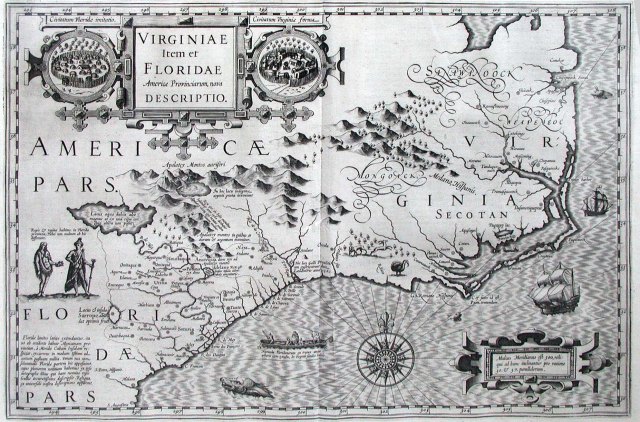
Virginiae Item et Floridae
This map by Jodocus Hondius first appeared in the 1606 Mercator’s atlas, published by Hondius. As noted by William P. Cumming (The Southeast in Early Maps), Hondius relied primarily on de Bry’s engravings of White’s and LeMoyne’s maps of Virginia and Florida, respectively. As a result, the coastlines of South Carolina and Georgia are greatly reduced.
The Dutch archives holds this map and you can see it at this link (thanks to our friend Yvette at the archives):
Notice the 3 separate Indian towns on Hatteras Island one on Ocracoke. Of course, the one we all know about on Roanoke Island near the colonist’s fort is shown as well as the companion village across the sound at Dasamoriquepeuc.

But aside from all the cartographic history, I love the turkey!


Interesting that the Saawanoock (Chowan) tribe, the Mongoak (Tuscarora) tribe and the Weapomoc tribe were all written in large flourishing letters whereas the Secotan was plain, but bold, unflourished letters. Also note the two types of villages shown. While both were inside log enclosures, one had sharpened posts and the other did not . One had bark covered long houses and the other had smaller thatched huts.
You know, it almost seems like both the Chowan and Mongoak were general places while some of the other villages were specific locations. What do you think? I’m sure you’ve noticed too that the map is not oriented to north.
I actually have this map framed but never knew anything about it. Thanks, ~bea~
Date: Thu, 3 Jan 2013 18:07:12 +0000 To: lerbea@hotmail.com