
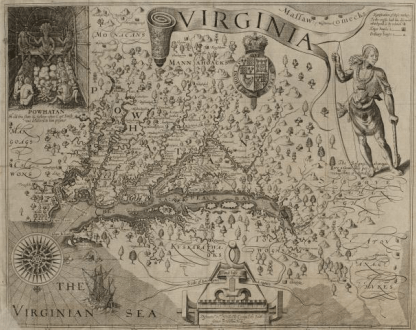
Our friend Yvette in the Dutch archives has done it again. I’m so glad she loves maps as much as I do. This map is particularly interesting though, because it is of the James River area, near Jamestown, discovery attributed to John Smith, the founder of Jamestown, drawn by William Hole. This, of course, dates the map to about 1608 when Smith explored the Chesapeake Bay region. He left Jamestown in October 1609, for England, due to a gunpowder accident. In 1614, he was exploring the New England region, but did not further explore the Chesapeake, at least as far as I can find. Smith died in 1631 in England.
This map was included in the 1624 book, The Generall Historie of Virginia, New-England, and the Summer Isles.
Here is a link to the entire map. I love the Dutch archives and how they handle maps. You can enlarge and scroll around to your heart’s content without losing resolution.
This map clearly shows Point Comfort, Cape Henry and Cape Charles.
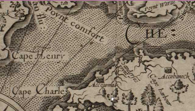
All of these sights are the mouth of the Chesapeake Bay. This site provides a significant amount of information about this area, militarily, along with some nice maps. http://www.virginiaplaces.org/chesbay/chesattack.html
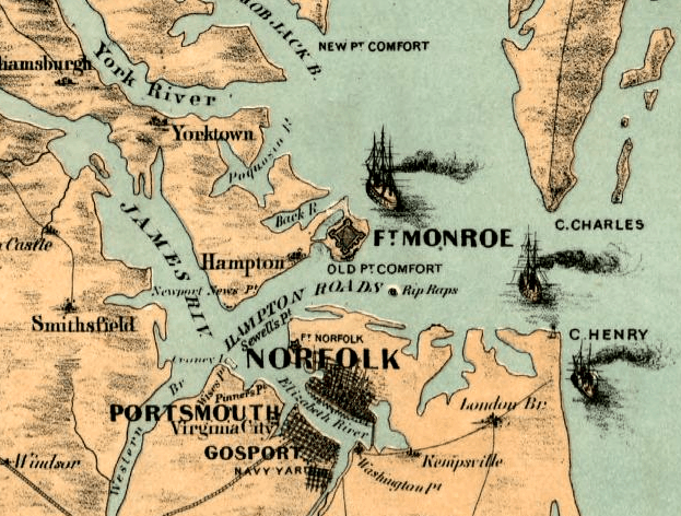
This older map from the Library of Congress in 1861 shows the location of all three of these landmarks.
But look again at the older James River map. It also shows the location of Accohonock.
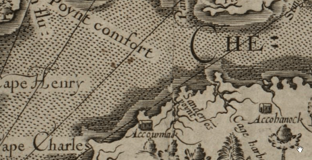
Jan. 2, 1608 – John Smith returns to Jamestown with information that there were “at a place called Acanahonan certain men clothed like me.” On this map are two locations with similar names, Accowmak or Accowmack and Accohanock. Could one of these be Accohonock.
If you’re thinking to yourself that the spelling isn’t the same, you’re right. Spelling was not yet standardized in the English language at that time. And make note of something else on this map.
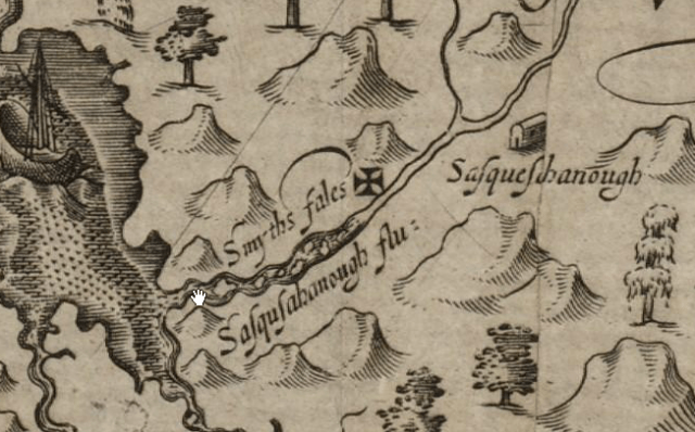
The word Sasquesahanougs is spelled three different ways, on the same map.
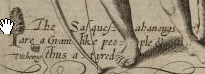
Below the drawing of the Native man, the legend says “the Sasquesahanougs are a gyant like people and thus attired.” This is quite interesting.
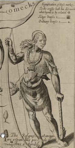
Does anyone know what animal the man has hanging from his back. It looks kind of like a pig.
In any event, further down the map, where the location of the Sasquesahanougs is shown, the name is spelled two ways: Sasqusahanough flu= and Sasques_hanough. The underscore means that there is a letter I can’t read due to the crease.
We’ve learned a lot from this map. First, we may have a location for Acanahonan where one of the Lost Colonist sightings took place. Secondly, we know where the villages are located, and the chief’s homes. Third, we know that the Sasquesahanough’s were giant-like men.
Thanks so much Yvette. You keep on looking for those colonists!!! The Jamestown fort location was found on a Spanish map, so why not the colonists in the Dutch Archives????

Wow, I had no idea this map would bring you so much new information! That’s just great 🙂 If you search the http://www.gahetna.nl website for ‘Virginia’ you will find some other maps, including an interesting manuscript map that unfortunately only shows the first part of the Chesapeake.
About ” Sasqusahanough flu=”, “flu=” is an abbreviation for “fluvius”, Latin for ‘river’.
I wouldn’t be surprised if we have more early Virginia maps in the collection. Some of the best map makers in the world in the 17th century were working in Amsterdam. Also, the Dutch East Indies and West Indies Companies produced a lot of maps to document where to trade. The archives of those companies are kept at the National Archives. The total map collection of the National Archives is over 300,000 maps large. What makes the collection special is that most maps are manuscript maps (hand-drawn or painted), and not printed. That is because these maps were created as part of the day-to-day activities of governments and companies, not maps that were created for decoration.
So what you are telling me is that I could spend the rest of my life there is there was a place to eat and sleep:)
Yes, really! In the same building we have the Royal Library, the Central Bureau of Genealogy, the National Center for Art Documentation and the Literary museum. Oh, and a restaurant. No hotel though! It’s a fascinating place to work. I often get kicked out by the guards myself 🙂
This is incredible! I had no idea that you find information about Jamestown in the Dutch archives! While you’re at it, if you happen to come across anything about my ancestor John Proctor, one of the early settlers of Jamestown or his wife Allis/Alice, please let me know. I am also interested in anything about Nathaniel Tatum, another early Jamestown settler. Thanks for sharing the awesome map, Roberta and Yvette! 🙂
Me again. 🙂 Can you please tell me if this book that you mention is in English and if it accessible online: 1624, The Generall Historie of Virginia, New-England, and the Summer Isles? Thank you!
Yes it is available. It’s ‘olde English” but certainly still understandable. Here’s the link. http://docsouth.unc.edu/southlit/smith/menu.html
@CeCe Moore Unfortunately, most of the West Indies Company archives were sold as scrap paper in the 19th century. All that remains are the proceedings of the administrators. There is hardly any information about the population living in the Colonies, not even the Dutch ones. But I will keep my eyes open for any records that may be of interest to people with early US roots!
Oh, this hurts my heart…..scrap paper.
Yes, isn’t it terrible? We have close to a mile of shelves with Dutch East Indies Company Archives and only 40 feet or so of the West Indies Company Archives. The East Indies Company archives include a lot of genealogical gems like the ship’s logs and manifests, including the names of hundreds of thousands of people who traveled on those ships. The same types of documents once were kept in the West Indies Company archives. It’s not quite a loss on the scale of the library of Alexandria, but for all of us with an interest in the New Netherland period, it is a close second!
This is a lovely map.I am wondering about “Smyths Fales” shown located across the river from Sasquesahanough.It seems to be marked by the cross next to it.I seem to remember that an eyewitness to the “canoe” graves found at Beechtown NC described the coffins as having something like a Moline cross carved on them.It seems that this same style of cross is repeated many times as almost a trademark of the colonists…I have a sneaky suspicion that it was this style of cross that was carved on the famous Croatan tree.
Crosses on these types of maps typically denote ‘end points’ to indicate how far they have explored the area. If you look at the full size map, you will see that they are on several other points of inland rivers as well. If this interpretation is correct, they have nothing to do with actual landmarks.
another interpretation is that the crosses show how far the rivers are navigable. Either way, they have nothing to do with real graves.
It actually says that in the legend if you scroll around. My interpretation was that they had explored to that point, but not beyond and they were marking it as such. It is interesting that they chose the cross for that. The cross much have been used quite a bit, which may be why White chose it as the method that the colonists were going to use to warn him if they left under duress. Bu there were no crosses carved at Roanoke, which told White that they did not leave under pressure, they simply moved. He was “greatly joyed” by this as he reports in his 1590 journal.
Thanks for the reminder that the cross didnt actually get carved on the tree….Still i am curious about the crosses on those Beechwood coffins and if they would have borne any resemblence…Bring on the maps! Thanks again.
Hi Mavis. If you’re interested, I wrote a paper about Beechland, where those coffins were found. It’s on my webpage at this link: http://www.dnaexplain.com/Publications/PDFs/BeechlandOralHistoryvsHistoricalRecords.pdf