
Louis Jolliet (sometimes spelled Joliet) and Jacques Marquette are credited with the (European) discovery of the Mississippi River.
Jacques Marquette (also known as Father Marquette) was a Catholic missionary and explorer. He was born in Laon, France. In 1666 he came to Québec, Canada and learned Indian languages. From 1669 to 1671 he worked in missions in Sault Sainte Marie (Michigan) and La Pointe (Wisconsin). Around this time, he first met Louis Jolliet, who was trading with Indians in the same area.
Louis Jolliet was a French-Canadian trader and explorer . Jolliet was born near Québec City and raised in a Jesuit seminary. In 1668 he decided that he didn’t want to become a priest and he became a trader with the Indians instead. From 1669 to 1671 Jolliet explored a lot of the Great Lakes region. During that time he became a great map maker, also worked as a fur trader, and met Marquette.
In 1672, Jolliet was named leader of an expedition that would explore the northern part of the Mississippi River the following year. Jolliet asked Father Marquette to be the chaplain of this group.
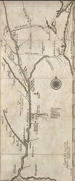
This 1681 map of the Marquette and Jolliet 1673 exploration shows a number of tribes and locations, including the iron mines, “choauanons mines de fer.”
On May 18, 1673, Louis Jolliet and Jacques Marquette departed from St. Ignace, now a part of Michigan, with two canoes and five other voyageurs of French-Indian ancestry (today’s Métis). They followed Lake Michigan to Green Bay, now in Wisconsin. They then sailed up the Fox River (Wisconsin) to a distance of slightly less than two miles through marsh and oak plains to the Wisconsin River. At that point Europeans eventually built a trading post, Portage, named for its location. From there, they ventured on and entered the Mississippi River near present-day Prairie du Chien on June 17.
The Jolliet-Marquette expedition traveled down the Mississippi to within 435 miles of the Gulf of Mexico, but they turned back north at the mouth of the Arkansas River. By this point, they had encountered natives carrying European goods, and they were concerned about an encounter with explorers or colonists from Spain. They followed the Mississippi back to the mouth of the Illinois River, which they learned from natives was a shorter route back to the Great Lakes. Following the Illinois and the Des Plaines rivers, via the Chicago Portage, they reached Lake Michigan near the location of modern-day Chicago. Marquette stopped at the mission of St. Francis Xavier in Green Bay, Wisc., in August, while Jolliet returned to Quebec to relate the news of their discoveries.
On his way back to Québec, when Jolliet was on Lake Michigan, his canoe turned over and all his precious maps and journals of his trips were lost, but he was able to replace most of the information from memory.
The party returned to the Illinois Territory in late 1674, becoming the first Europeans to winter over in what would become the city of Chicago. As welcomed guests of the Illinois Confederation, the explorers were feasted en route and fed ceremonial foods such as Indian corn.
After the expeditions, Father Marquette remained by Lake Michigan and preached among the Illinois Indians until his death in 1675.
In the spring of 1675, Marquette traveled westward and celebrated a public mass at the Grand Village of the Illinois near Starved Rock. A bout of dysentery which he had contracted during the Mississippi expedition sapped his health. On the return trip to St. Ignace, he died at age 37 near the modern town of Ludington, Michigan.
Louis Jolliet later explored other parts of Canada, such as Labrador and Hudson Bay. He died in 1700 at the age of 55 after disappearing on a canoe trip. His body was never found.
You can read more about the expedition here: http://library.thinkquest.org/4034/marquettejolliet.html
Thanks to Fletcher for sending the map and identifying the mines!
